Earthquakes on the Move in the Midland Basin
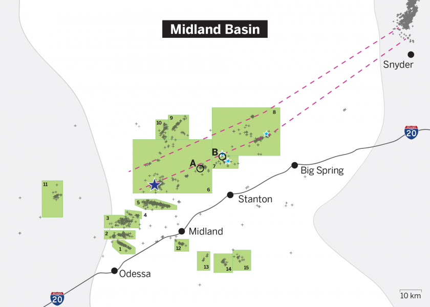

Since 2017, researchers at the Bureau of Economic Geology have been using TexNet, a statewide seismic monitoring network, to track earthquakes across Texas. Now, they are applying the data to new ends: to forecast where earthquakes could be going next.
In a study published in Seismological Research Letters, a team of scientists from the Bureau of Economic Geology described how seismic activity in the Midland Basin appears to be on the move.
In the past, most quakes happened in the southwest region near Odessa and Midland. The activity is now probably heading northeast toward the community of Big Spring, with the seismicity moving along a newly identified and extensive seismogenic fault zone stretching toward the northeast edge of the basin.
“The fault zone has been activated, and it has the capability to trigger additional earthquakes that can be felt by humans, especially because it’s so close to major cities along Interstate 20,” said Dino Huang, a research assistant professor at the bureau who led the research.
Huang and collaborators used seismic data from TexNet to calculate the depth, location and orientation of geologic faults — large cracks under the ground where earthquakes can occur — using a technique called passive seismic analysis. This analysis allowed the researchers to find previously unmapped parts of the Midland Basin fault system. Major features of the system include what looks like a rift structure stretching across the middle of the basin in the deep basement rock that is slowly widening over time. This rift structure is surrounded on either side by a complex network of smaller faults.
Within this fault system, the researchers identified 15 distinct earthquake-producing zones — places where earthquakes have already occurred and where the quakes can be traced back to common sources of stress in the subsurface. The researchers then combined the data on earthquake frequency and magnitude from all the zones to determine the future seismic potential of the entire Midland Basin — that is, the potential for future earthquakes to occur.